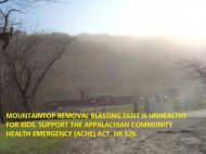
Alpha Natural Resource's subsidiaries Marfork Coal Company and Republic Energy have five approved surface mining permits (Bee Tree, Eagle 2, Middle Ridge, Collins Fork, and Long Ridge #1) and one pending permit (Center Contour) on Coal River Mountain. In total, these permits cover over 5,600 acres of the mountain. In addition, they have permits for the Brushy Fork sludge dam (slurry impoundment) for 645 acres and the old Workman's Creek sludge dam for 289 acres. Alpha is actively mining where the Workman's Creek, Collins Fork, and Middle Ridge sites come together.  Active mountaintop removal on Coal River Mountain, March 8, 2016. Flyover courtesy of Southwings (www.southwings.org).

Map courtesy of Journey Up Coal River
Update
As of May 2018, active surface mining is occurring in an area that includes parts of the contiguous Middle Ridge, Collins Fork, and Eagle 2 sites, as well as the nearby Long Ridge #1 site.
- Mining on the Bee Tree permit was idled in May 2012, due to a drop in international demand. Before mining stopped, Marfork had destroyed about 71 acres of the 1,096-acre permit. If coal market conditions improve, mining could resume at any time. This site joins the Brushy Fork sludge dam. Rather than getting valley fill permits, Alpha just jumped the overburden into Brushy Fork.
- The 264-acre Collins Fork permit has been extensively mined, turning a large chunk of forested mountain into dusty rubble. Alpha has applied for a revision in order to delay reclamation and use the site as a landfill for their used tires. Coal River Mountain Watch appealed the West Virginia Department of Environmental Protection (DEP)'s decision to approve this permit to the state Surface Mine Board. We argued that the DEP failed to properly evaluate the cumulative effects of strip mining in the watershed of the Clear Fork of the Coal River, including the impact on human health. DEP also refused to grant CRMW an inspection of the permit prior to the permit hearing and the agency also blatantly disregarded a statute requiring the permit hearing to be held within 3 weeks of the public comment period; instead the hearing was held 3 years later. The Surface Mine Board issued its decision in May 2012. Despite agreeing that the DEP "flagrantly" violated the law regarding public input and comment on the permit, the Board did not reverse the DEP's approval of the permit.
- The 800-acre Middle Ridge permit, previously called Leather Leaf and Eagle 3 before that, has been extensively mined. Coal River Mountain Watch revealed a pattern of sediment control violations that resulted in the WVDEP imposing a consent order on the company.
- The 2,000-acre Eagle 2 permit should be null and void according to federal law, which requires mining to commence within three years of the permit being granted unless an extension is obtained. Marfork failed to begin mining or apply for an extension within three years, but the DEP retroactively granted them an extension for none of the legal reasons to do so. In June 2012, the Charleston Field Office of the federal Office of Surface Mining (OSM) responded to a citizen complaint from Coal River Mountain Watch and agreed that the DEP's actions were “arbitrary, capricious, and an abuse of discretion.” DEP appealed the decision, and the OSM undersecretary overruled the Charleston Field Office, determining that the word "shall" in the law does not carry a mandatory obligation. CRMW sued the OSM in federal court for effectively creating a national rule without complying with legal procedures to do so. OSM used their same determination to approve a mine in Alaska. A court ruled against OSM in the Alaska case. Subsequently, in December 2016 our court granted OSM's motion to vacate the undersecretary's decision and remand it for "expeditious" reconsideration in light of the Alaska case. Nearly two years later, the OSM has still not released their decision, and mining has begun on Eagle 2.
- The 847-acre Long Ridge #1 permit application was advertised in spring 2015. CRMW generated significant opposition to this permit, turning out about two dozen people to the informal conference and generating over 73,000 online petition signatures. The permit was approved anyway and mining has begun.
- The 561-acre "Center Contour" permit application was advertised in April 2016, and an "informal conference" was held where we opposed the permit in July 2016. The permit has still been neither approved nor denied, in spite of law requiring the DEP to decide within 60 days of the informal conference.

Our current analysis of the majority of proposed mining on Coal River Mountain is that the coal mined will primarily be sold as metallurgical coal (used for steel production), rather than thermal coal for electricity generation.
Past mining operations, and the potential for future mining, have raised concerns about the stability of the Brushy Fork Impoundment. A slurry impoundment is a huge pond, held back by an earthen dam, containing the toxic residue left over from the process of washing coal before it is burned in a power plant. All of the chemicals (some of which are carcinogenic) used in the washing process, as well as the heavy metals and other minerals removed from the coal are part of the slurry. At the current stage the dam is impounding about 5.5 billion gallons of coal slurry with a capacity of about 7.5 billion gallons.
The Bee Tree permit is adjacent to the Brushy Fork Impoundment, and there are serious concerns that future blasting on this permit may increase the risk of dam failure or impoundment basin failure by cracking the less than 200 feet of inter-burden between the toxic coal slurry in the impoundment and unstable underground mines below. A dam failure would be similar to that of the Buffalo Creek disaster in 1977 which killed over 100 people. A basin failure would be similar in nature to that of the Martin County Kentucky coal slurry disaster in 2001 where slurry leaked into abandoned underground mines and burst out the side of the mountain. The Brushy Fork impoundment is impounding over 10 times more slurry than both Martin County and Buffalo Creek. According to the Emergency Evacuation Plan prepared by Marfork, a failure of the dam would send a wall of slurry down the Coal River for more than 25 miles. (More information on the Brushy Fork Impoundment and the Emergency Evacuation Plan).
Coalfield residents know how powerful surface mine blasting is, as they feel in their homes even when it is miles away. Portions of the dam and pond are sitting just 150 feet above abandoned underground mines. Marfork Coal Company, Marfork’s Consultants, the WV Department of Environmental Protection (DEP), and federal Office of Surface Mining Reclamation and Enforcement (OSMRE) assured the public that proper engineering review considerations have been made to address stability issues in the mine complex beneath the impoundment.
During a series of reports from 1999 to 2004 it was discovered by Marfork consultants that several pillars failed to achieve the desired long-term safety criteria. Marfork consultants and the DEP determined that given the abnormally dry conditions in the coal seam beneath the dam, weathering and deterioration of pillar strengths was not likely to occur. The last known site visit by the WV DEP to inspect the pillars was in 1999 and Marfork likely performed underground inspections as late as 2001. Due to conflicting reports it is hard to tell whether conditions in the coal seam under the impoundment currently are dry or wet (wet conditions would be more likely to lead to pillar failure and breakthrough).
Marfork has a current application to raise the crest of the dam to its next stage; however, this plan has not yet been approved by MSHA due to stability concerns. MSHA claims the dam is safe but has concerns about the stability of the dam if wet material in a portion of the dam is used as a foundation for making the dam larger.


